12). As early as 8 April John Allin wrote to Philip Fryth: ‘Our fleete is sickly, and ye sicknesse increases at Yarmouth’ (Archaeologia 37 (1857), 18. 5).
great Engagement at Sea: the battle off Lowestoft, 3 June 1665.
Vain … Man: Psalm 9: 11.
Physicians … all supernatural: see second note to p. 65.
ten Lepers … healed: Luke 17: 12–17.
sang his Praise … his Works: Psalm 106: 12–13.
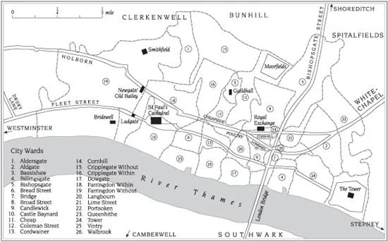
The City of London in the late seventeenth century
TOPOGRAPHICAL INDEX
THIS index is comprehensive in respect of London but excludes towns nearby such as those listed on p. 132 and ports named on pp. 186–7 and 189. Where appropriate, information from Louis Landa’s 1969 select Topographical References has been incorporated but the aim is to provide only information that is directly relevant to the Journal, its manifold contexts, Defoe’s ‘double’ vision of London pre- and post-Fire, and to the task of helping readers follow H.F.’s meanderings through the city and its lore. Ben Weinreb and Christopher Hibbert’s The London Encyclopaedia, 3rd edn. (London, 2008), a principal source here, is recommended to those seeking more detail. Manuel Schonhorn’s 1968 article—details in the Select Bibliography—is a key reference point. Information has also been drawn from Norman Brett-James, The Growth of Stuart London (1918); Defoe’s A Tour thro’ the Whole Island of Great Britain (1724–6), ed. G. D. H. Cole (1927) and his Due Preparations for the Plague, ed. Aiken (1895); Henry A. Harben, A Dictionary of London (1918); Edward Hatton, A New View of London (1708); Jacob Larwood and John Camden Hotten, English Inn Signs (1951); John Stowe, A Survey of the Cities of London and Westminster, 6th edn., ed. John Strype (1754); and Henry B. Wheatley and Peter Cunningham, London Past and Present (1891). Useful maps are those by Richard Newcourt (1658), John Oliver (1676), John Ogilby and William Morgan (1677), and Robert Morden and Philip Lea (1682, rev. 1732); a sketch of Defoe’s City is reproduced in this edition.
The term ‘City’ is used to signify the area of London north of the Thames extending from the Tower westwards as far as Whitefriars and north to Cripplegate. Where applicable the places listed below are keyed, in brackets following the name, to the ward numbers given on the map.
ALDERSGATE (Ward 1) pp. 160, 198. Roman city gate near Smithfield, used to display regicidal limbs in 1660; repaired after the Great Fire and demolished in 1761.
ALDERSGATE STREET (Ward 1) pp. 62, 138. In the seventeenth century, a spacious, Italianate street leading north that was home to printers and, briefly, to John Milton’s Maidenhead Court boarding school.
ALDGATE (Ward 2) pp. 7, 14, 33, 42, 45, 52, 86, 88, 154, 160, 161, 162, 163, 178, 184, 208, 211. Named after one of six Roman gates, opening onto the Colchester road; rebuilt 1606–9, demolished 1761. Defoe was married at St Botolph’s, Aldgate, in 1684 and he imagined H.F.’s home as between there and Whitechapel Bars, the City boundary. H.F.’s ‘Broad street’ was Whitechapel.
1 comment