Amurath to Amurath Read Online
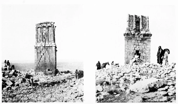
| Fig. 21.—SERRÎN, NORTHERN TOWER TOMB. | Fig. 22.—SERRÎN, SOUTHERN TOWER TOMB. |
CHAPTER II
TELL AḤMAR TO BUSEIRAH
Feb. 21—March 7
The Water of the Euphrates is much esteemed by the inhabitants of its banks. It is, I think, an acquired taste; the newcomer will be apt to look askance at the turgid liquid that issues from the spout of his teapot and to question whether a decoction of ancient dust can be beneficial to the European constitution. Fattûḥ, being acquainted with my idiosyncrasies in the matter of drinking water, accepted without a murmur the sacrilegious decree that that which was destined for my flask must be boiled; whereby, though we did not succeed in removing all solid bodies, we reduced them to a comparative harmlessness. But if it cannot be described as a good table river, the Euphrates is the best of travelling companions, and the revolution of the seasons will never again bring me to the last week of February without setting loose a desire for the wide reaches of the stream and the open levels of the desert through which it flows, the sharp cold of nightfall, the hoar frost of the dawn, and the first long ray of the sun striking a dismantled camp. “There is no road,” said Fattûḥ, “like the road to Baghdâd: the desert on one hand and the water on the other.”
Our way next morning took us past Ḳubbeh to Mughârah, which we reached in three hours. Here we left the river and climbing the low, rocky hill to the east, found ourselves in a stony and thinly populated country bounded by another ridge of eastern hill. After twenty-five minutes’ riding we saw the hamlet of Ḳayyik Debû about half-a-mile to the left of the track, and in another quarter of an hour we reached a few deserted houses. Four hours from Tell Aḥmar
we pitched camp on the further bank of a small stream near the village of Serrîn, for I wished to examine two towers which stand upon the crest of a high ridge about half-an-hour to the east. They are called by the Arabs the Windmills, but in reality they are tower tombs. The more northerly, which is the best preserved, is 4·20 m. square and two storeys high (Fig. 20). The walls of the lower storey rise in solid masonry to a height of about six metres and are crowned by a plain course of projecting stones, which serves as cornice (Fig. 21). On the east and west sides, just below the cornice, there is a pair of gargoyles, much weathered. They represent the head and fore-quarters of lions. A little below the pair of heads on the west side is a Syriac inscription, dated in the year 385 of the Seleucid era, i. e. A.D. 74, which states that the tomb was built by one Manu for himself and his sons. The second storey is decorated with fluted engaged columns, four on either side, the outer pair forming the angles. The bases of these columns rest upon a course of masonry adorned with three fasciæ: it is to be noted that the mouldings are not carried straight through to the angles, but are returned one within the other like the mouldings of a door lintel. The Ionic capitals carry a plain Ionic entablature consisting of an architrave with fasciæ, which are here taken through to the corners, a narrow frieze and a cyma of considerable projection. Probably the whole was surmounted by a stone pyramid.


1 comment